Kouroussa Prefecture (Kouroussa)
The majority of the prefecture's population comes from the Malinke and Djallonke ethnic groups, who speak related Mande languages and follow the Muslim religion. The Kouroussa area is the centre of the Hamana-Malinke Mande sub-group -- "Hamana" being the historic name for the region, while the Malinke are the major Mande speaking ethnic group of the upper Niger valley. There are also sizable minority communities of Fula and Dyula, the latter traditionally forming trade communities in towns like Kouroussa.
The writer and intellectual Camara Laye (1928–80) grew up in Kouroussa town, and his memoir, The Black Child, is in part about his youth in the town.
Kouroussa and surrounding towns maintain the pre-colonial Mande ceremonial kingship of Hamana, with the most recent holder of the office King of Kouroussa King Sayon Keita I.
Map - Kouroussa Prefecture (Kouroussa)
Map


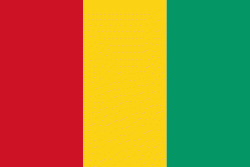
Country - Guinea
 |
 |
| Flag of Guinea | |
Formerly French Guinea, it achieved independence in 1958. It has a history of military coups d'état. After decades of authoritarian rule, in 2010 it held its first democratic election. As it continued to hold multi-party elections, the country continued to face ethnic conflicts, corruption, and abuses by military and police. In 2011, the United States government claimed that torture by security forces and abuse of women and children (including female genital mutilation) were ongoing human rights issues. In 2021, a military faction overthrew president Alpha Condé and suspended the constitution.
Currency / Language
| ISO | Currency | Symbol | Significant figures |
|---|---|---|---|
| GNF | Guinean franc | Fr | 0 |
| ISO | Language |
|---|---|
| FR | French language |